FLOOD WATCH – Mattawa River
A FLOOD WATCH has been issued for the Mattawa River downstream of Hurdman Dam to the Ottawa River. The FLOOD WATCH previously issued for Chippewa Creek has ended and a Watershed Conditions Statement – Flood Outlook remains in effect for the remainder of the North Bay–Mattawa watershed, including Chippewa Creek.
Current Conditions:
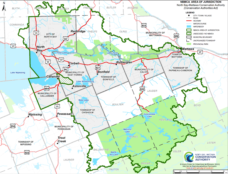
Water levels on inland lakes and rivers remain within the normal range for this time of year. Water levels have been rising on Lake Nipissing and the Ottawa River in response to recent rainfall and ongoing snowmelt from northern portions of the watersheds. Water level at the Ottawa River in Mattawa is slightly above normal. The water level on the Mattawa River downstream of Hurdman Dam is directly impacted by the water level on the Ottawa River. Soils have recently thawed and are near saturation, with limited ability to absorb rainfall.
Current water levels can be viewed by searching Station Names “Ottawa River”, “Mattawa River”, “Chippewa Creek”, “La Vase River”, “Wasi River”, and “Lake Nipissing” at https://wateroffice.ec.gc.ca/search/real_time_e.html
Forecasted Conditions:
Several rounds of rain are forecast for today (Apr 29) and Thursday (May 1) into Friday, with a 4-day total of approximately 45 mm of rain possible. Temperatures are forecast to be approaching 20 ºC during the day and slightly below freezing overnight over the coming week. Water levels and flows are expected to increase in response to the rainfall and melt of remaining snowpack, particularly in the northern reaches of the Upper Ottawa River watershed and northern tributaries to Lake Nipissing.
The water level on the Ottawa River at Mattawa has increased with increased discharge from upstream reservoirs. Upstream discharge is expected to continue increasing and water levels may reach the start of minor flooding by May 3 and then stabilize. Water levels on the Ottawa River are managed by upstream dams and reservoirs operated by provincial and federal governments. Forecasts are available at https://ottawariver.ca/.
The water level on Lake Nipissing is regulated by dams operated by the federal government. Water levels are expected to reach normal summer navigable water levels by the end of this week. Forecasts are available at https://www.canada.ca/en/public-services-procurement/services/infrastructure-buildings/bridges-docks-dams/frenchriver-dam.html
Historic Flood Conditions:
Risk:
Snowmelt in tributaries to Lake Nipissing and the Ottawa River, combined with recent and forecast rain is contributing to increasing water levels. A Flood Watch has been issued for the lower reaches of the Mattawa River, downstream of Hurdman Dam where water levels are directly influenced by high flows on the Ottawa River.
A series of rain events is forecast for this week. A Watershed Conditions Statement – Flood Outlook is in place for the remainder of the watershed. Rain on saturated soils quickly becomes runoff. Water levels in urban areas respond rapidly, especially during and after periods of intense precipitation. Localized flooding is possible in low-lying and flood-prone areas is possible.
All residents, especially those in low lying areas, are encouraged to monitor the conditions that are developing. Banks adjacent to rivers and creeks are very slippery at this time and when combined with cold open water, pose a serious hazard. The public is encouraged to keep children and pets away from watercourses and waterbodies.
Municipalities are encouraged to monitor water crossings for debris that may affect the movement of water through culverts and bridges. A close watch on local conditions and updated forecasts and warnings from Environment Canada is also recommended.
Staff at the North Bay-Mattawa Conservation Authority will continue to monitor weather and watershed conditions and update this message based on the changing weather and streamflow conditions.
Terminology: Notification Levels
WATERSHED CONDITIONS STATEMENT: general notices of potential flooding or other conditions that pose a safety risk. There are two kinds of statements:
Water Safety: indicates that high flows, unsafe banks, melting ice or other factors could be dangerous for users such as anglers, boaters, swimmers, children, or pets. Flooding is not expected.
Flood Outlook: gives early notice of the potential for flooding based on weather forecasts calling for heavy rain, snow melt, high wind or other conditions that could lead to high runoff, cause ice jams, lakeshore flooding or erosion.
FLOOD WATCH
FLOOD WATCH: notifies that the potential for flooding exists within specific watercourses and municipalities. Municipalities, emergency services and individual landowners in flood-prone areas should prepare.
FLOOD WARNING
FLOOD WARNING: notifies that flooding is imminent or already occurring in specific watercourses or municipalities. Municipalities and individuals should take action to deal with flood conditions. This may include road closures and evacuations.